Category: plans (Page 2 of 2)

Existing floor plans

Since we bought the property before any estate agents details were produced, these are the first floor plans of the property that we have seen.  We have been working off some of the rough sketches that I did using Google Maps as a source for the overall size and shape of the property.


Ground floor floorplan
Ground Floor

You can see quite clearly the outline of the three original cottages with the middle one being smaller than the two adjoining.  Interestingly, this fact is also borne out by the census records that show that the middle property consisted of just two rooms – one up and one down.  These days it is difficult to imagine bringing up a family in such a property.


First floor floorplan
First Floor

I didn’t want to publish any of this information until we had exchanged – it seemed to be tempting fate otherwise.
Topographic survey

We had a completed topographic survey of the property and the surrounding land completed last month.  The work was completed by Ben at VisionGeomatics.  More on their website here: www.visiongeomatics.com.


Topographic Survey
Excerpt from the topographic survey


You can download the entire survey as a PDF here.  This allows you to turn the layers on and off on the survey plan. There is an incredible amount of data on the topographic survey including contours, outbuildings, trees, drains, overhead power lines and walls.

The survey data includes all the land as well as an outline of the buildings.  A separate internal survey was completed to work out the floorplan for the buildings. You will find the floorplans here. These floor plans were then placed onto the topographic survey to provide a complete picture of the buildings and site.  This should be a great starting point for the new designs.

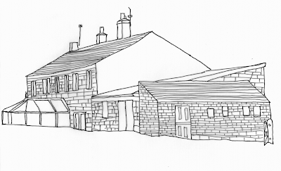
The farm today (drawings)

Here’s a couple of drawings of the farmhouse as it is today.  The second drawing shows the property in less detail, but labels up the different parts that go to make up the building.  You will find photos of the property here.

The cottages were originally three cottages (8, 9 and 10 Hagg Leys).  It was only in the 1990s that numbers 9 and 10 were converted into one property – known as 10 Hagg Leys today.  We plan to join all three cottages together and connect it to the barn.


Drawing of the existing properties
Drawing of the property today


The barn is a simple construction with a sloping corrugated roof.  There are two floor levels inside the barn.  The lower floor level is probably at about the same level as floor level inside the cottages themselves. The current plan is that the barn will form the corner of an extension that will be at a right angle to the existing cottages.  Thus forming an “L” shape.


Outline drawing of the existing properties
The different parts that make up the property


Attached to the barn is another building with a lean-to roof.  This time the roof is made up of stone tiles.  It is believed that this building was used to prepared food for animals.  For want of a better label, I have called this the “piggery” since we believe that the food prepared here was destined for pigs. This building is likely to be demolished as part of the renovation and wherever possible the materials reused elsewhere on the site.

Plans of the property today

We have made some progress over the past couple of weeks.

The topographic survey was conducted a couple of weeks ago and we now the results.  It is a very accurate plan of the cottages, the outbuildings and the surrounding ground.  The surveyors installed a number of anchor points and then measured everything from these.  The end result is a very large plan of the property and the surrounding areas.

We also had a comprehensive internal survey completed.  From this, we now have an accurate layout of all the rooms, windows and even wall thicknesses.  This will be used as the basis for the plans for the new renovation.  The plans of the current building will also include the front and side elevations. 

I have both of these plans printed out on large sheets of paper, but I don’t have these electronically at the moment.  More when I have more information electronically.

Update: I now have electronic versions of the material and have uploaded them to other posts on the blog.  You will find the existing floorplans here, the topographic survey here, and the elevations here.

Newer posts »

© 2025 Hagg Leys Farm

Theme by Anders NorenUp ↑